Sun, Heat, and Midnight Thunder: D.C. Braces for a 70-Degree Saturday Surge
Morning Fog Gives Way to a Record-Challenging Afternoon
Washingtonians waking up this Saturday, March 7, 2026, might be greeted by a gray and dampened landscape, but local meteorological data suggests that residents shouldn't let the early mist fool them. The District is currently experiencing a dramatic weather swing as a surge of warm air pushes through the region, bringing some of the highest temperatures seen so far this year. While the day started with thick fog and cool air entrenched across the Metro area, a significant clearing is expected by midday.
Early morning temperatures remained brisk, hovering in the 40s and low 50s, but as the sun begins to break through the cloud cover, a rapid warming trend will take hold. This shift marks a sharp departure from the chilly start of the month, offering a temporary "fake spring" for those heading outdoors.
The Afternoon Peak: A Taste of May in March
By mid-afternoon, Washington D.C. is expected to see the mercury climb significantly. Forecasts indicate daytime highs reaching between 67 and 72 degrees Fahrenheit—a notable jump above the historical March average of 57 degrees. Strengthening southerly and southwesterly winds will pick up speed, gusting between 10 and 15 mph, which will help drive the warm-up. While the warmth is a welcome reprieve, residents should expect high humidity levels near 95%, making the air feel heavier than usual for this time of year.
Evening Storms and Rainfall Alerts
As evening approaches, the weather narrative will take a more turbulent turn. A line of scattered showers and potential thunderstorms is currently closing in from the west. Residents should be aware of the following timing and risks for the remainder of the day:
- Late Afternoon: Isolated spotty showers may develop after 4:00 PM, though most outdoor plans should remain safe until sunset.
- Evening and Late Night: A more organized line of showers and thunderstorms is projected to move through the Metro area late Saturday night. While the overall risk is low, there is a possibility that an isolated storm could become severe.
- Precipitation: While the daytime chance of rain is limited to 10%, the probability of precipitation jumps to roughly 35% overnight.
Important: Spring Forward Tonight
In addition to the shifting skies, the District is reminded that this is the weekend for the annual transition to Daylight Saving Time. Clocks should be set ahead one hour at 2:00 AM Sunday. While this means losing an hour of sleep, it results in a much later sunset tomorrow at 7:08 PM. With storms expected to move through overnight, it is advised to secure any loose outdoor items and keep an eye on local radar if traveling late this evening.
Capital Sunrise: Peak Bloom Fever and a Century of Basketball Magic
District Bulletin: Potomac Health Advisory Lifted and 2026 Public Service Deadlines
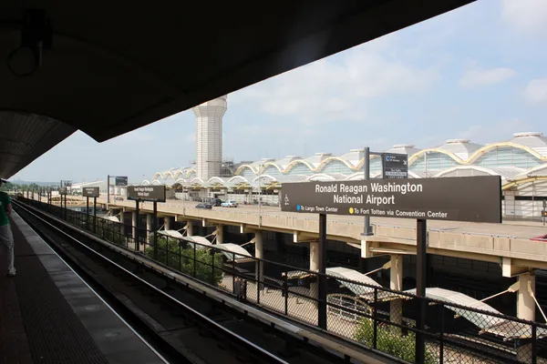
National Airport Station Closed: Major Metro and Road Delays This Saturday, March 7