Record-Breaking Freeze: D.C. Braces for Bomb Cyclone and Sub-Zero Wind Chills
A Historic Chill Grips the Capital
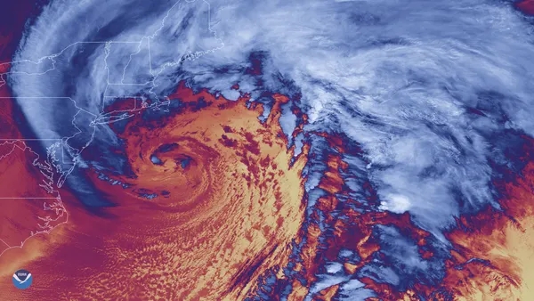
Washington D.C. is bracing for what could be the coldest January 31st in recorded history. As a powerful "bomb cyclone" intensifies off the Mid-Atlantic coast, residents are facing a combination of record-shattering low temperatures and a biting wind chill that is expected to plunge well below zero by nightfall. The city, already weary from a long-running cold snap, must now prepare for the peak of this Siberian-fed Arctic blast.
Morning and Afternoon Outlook
Saturday began with a heavy layer of cloud cover and temperatures hovering in the low teens. Forecasters are predicting a daytime high of only 21°F. If the mercury stays at or below this mark, it will officially break the previous record for the coldest high temperature ever recorded on this date—a record of 22°F that has stood since 1936. While winds will remain relatively light during the afternoon at roughly 10 to 15 mph, the lack of sunshine means there will be little relief from the pervasive cold.
Evening Deterioration and the "Bomb Cyclone"
Conditions are expected to deteriorate rapidly as we move into the evening and overnight hours. While the coastal nor'easter is tracking far enough offshore to spare the District from heavy snowfall, its rapid intensification will draw punishing winds into the region. Weather models indicate the following for tonight:
- Wind Speeds: Sustained northwest winds of 20 to 25 mph with gusts reaching up to 40 mph.
- Temperature Drop: Lows will plummet to approximately 10°F, though some outlying areas may see single digits.
- Wind Chill Warning: The real danger arrives after midnight, with wind chills expected to drop to between minus-5 and minus-10 degrees Fahrenheit.
Safety and Warnings
A Gale Warning is currently in effect for the local waterways, and city officials are urging residents to limit time outdoors tonight. The existing layer of hard-packed ice and snow—famously dubbed "snowcrete" by locals—is not expected to melt, creating continued hazards on secondary roads and sidewalks. Exposure to these temperatures can lead to frostbite in as little as 30 minutes, so it is imperative to dress in multiple layers and ensure pets are kept indoors. This extreme cold is expected to linger into early Sunday before the storm moves out to sea and the winds begin to ease.