Dense Fog Advisory for Maryland and Virginia prompts slower commutes across the Washington region Tuesday morning
Advisory covers multiple jurisdictions during the morning commute
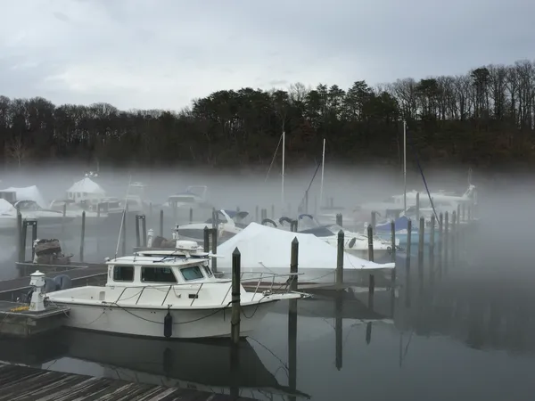
A Dense Fog Advisory was issued for parts of the Washington region on Tuesday morning, Feb. 17, 2026, covering portions of Maryland and Virginia during the height of the commute. The advisory area included sections of central, north-central and northern Maryland, as well as central, northern and northwest Virginia, with reduced visibility expected to create hazardous travel conditions. The advisory was scheduled to remain in effect until 11 a.m.
What dense fog means for drivers and transit
Dense fog advisories are issued when visibility is expected to drop significantly, sometimes to a quarter mile or less, increasing the likelihood of roadway incidents, delays, and chain-reaction crashes. In the Washington region, fog can be especially disruptive on higher-speed corridors and at known low-lying trouble spots near rivers and valleys, where moisture can pool overnight. Conditions can also vary sharply over short distances, making visibility changes difficult to anticipate.
- Allow extra travel time and expect sudden visibility drops on highways and ramps.
- Use low-beam headlights; high beams can reflect off fog and worsen glare.
- Increase following distance and avoid abrupt braking.
Why fog formed and when it was expected to improve
The advisory coincided with a pattern of milder air arriving after a colder period, a setup that can raise near-surface humidity and favor fog development overnight into early morning. With temperatures starting in the 30s, widespread low clouds and fog were most likely early, followed by gradual improvement as daytime heating strengthened and mixing increased.
Forecast conditions for Tuesday indicated fog and low clouds early, with brighter skies developing later in the day and afternoon temperatures rising into the 50s in parts of the region. A warmer stretch was expected to continue midweek, with temperatures approaching 60 degrees at times.
Looking ahead: additional rain chances later this week
While the primary near-term impact was confined to Tuesday morning’s visibility, the broader forecast trend pointed to a more unsettled pattern later in the week. A slight chance of rain was expected to develop on Wednesday, with additional rain chances increasing later in the week, which could further affect commutes depending on timing and intensity.
Forecast confidence is typically highest for near-term visibility hazards such as dense fog within the same morning, and lower for precipitation timing several days out.
Residents across the advisory area were urged to adjust morning plans, monitor changing conditions, and use caution on area roads until visibility improved later in the morning.