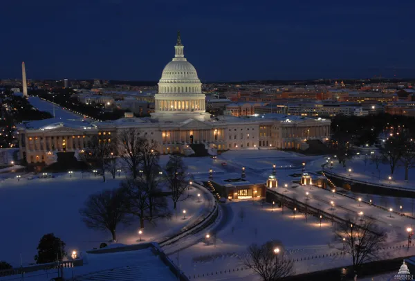
Arctic Grip and Midnight Snow: D.C. Braces for a Historic Winter Storm
A Frigid Start to the Weekend
Washington D.C. woke up to some of the most punishing cold the region has seen in years this morning, Saturday, January 24, 2026. As an intense Arctic blast settles over the Atlantic Corridor, temperatures at dawn hovered near 15 degrees Fahrenheit, though biting north winds from 10 to 15 mph made it feel closer to zero. Early morning commuters and residents were met with clear but deceptively sunny skies that offered little in the way of warmth. This frigid start serves as the opening act for a major winter storm system poised to paralyze the nation’s capital over the next 48 hours.
Afternoon Clouds and Record Chills
As we move through the afternoon, the bright morning sunshine will quickly give way to increasing cloud cover. High temperatures are expected to struggle significantly, likely peaking in the upper teens to low 20s. These temperatures are nearly 20 degrees below the seasonal average, and with gusts continuing to blow from the north, the 'feels-like' temperature will remain in the single digits throughout the day. Residents are urged to limit their time outdoors, as the National Weather Service has warned that this combination of record-setting cold and wind presents a significant risk for frostbite and hypothermia.
Midnight Snowfall and Accumulation Projections
The primary concern for the District begins late this evening. Light snow is predicted to start falling around 10:00 p.m., quickly becoming steadier and more intense by midnight. A Winter Storm Warning officially takes effect at 11:00 p.m. tonight. Meteorologists are forecasting a 'cement-like' heavy snow that will accumulate rapidly overnight. Current projections suggest the Beltway area could see between 5 and 9 inches by Sunday morning, while the District's far northwest suburbs could see over a foot. Visibility is expected to drop below a half-mile as the storm intensifies into the early hours of Sunday.
Emergency Declarations and Safety Notices
In response to the impending weather, Mayor Muriel Bowser has declared a State of Emergency. A Snow Emergency is officially in effect as of noon today, meaning motorists must move their vehicles off designated snow emergency routes or face ticketing and towing. The D.C. National Guard has been mobilized to assist first responders, as the heavy, wet nature of the snow—combined with the sub-freezing temperatures—raises the risk of power outages and fallen trees. Travel tonight and Sunday is strongly discouraged, as roads are expected to become treacherous within an hour of the snow's arrival.